Walking Routes
Shropshire Council Public Footpath 47R Woore Road Traffic Regulation Act 1984 - Section 14 (2)
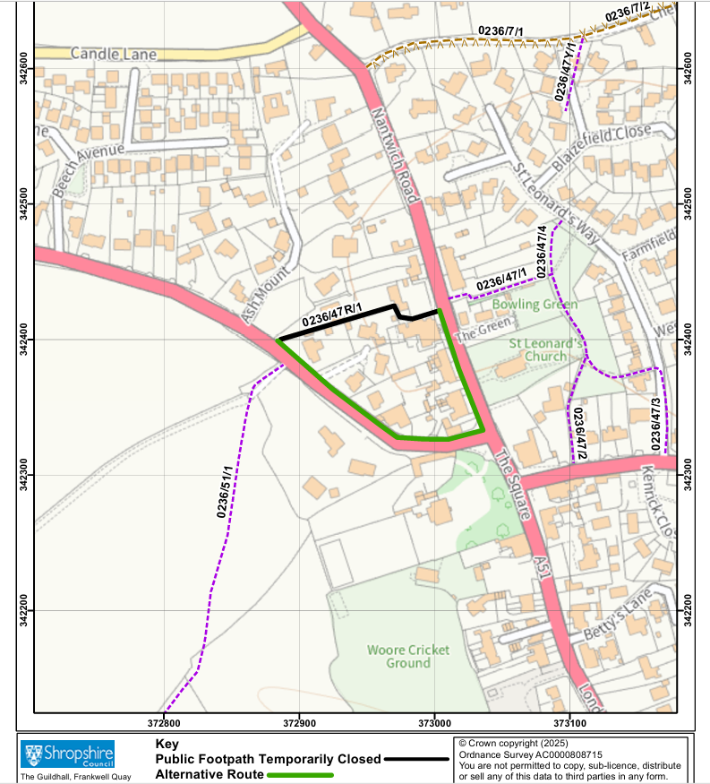
Temporary Prohibition of Use of Public Footpath Shropshire Council hereby gives notice under Section 14(2) of the Road Traffic Regulation Act 1984 prohibiting the use of Public Footpath 47R in the Parish of Woore which runs from its junction with the A51 (Nantwich Road) at grid reference SJ 7299 4242, in a general west-south-west, then west-north-west, then north-north west, then west-south-west direction enclosed between residential properties to its junction with the A525 (Audlem Road) at grid reference SJ 7288 4239 and as shown by a continuous bold black line on the Emergency Temporary Closure Map. It is intended that the proposed restriction will come into force on the 29th July 2025 and be in place for a 21-day period, in the first instance. It is required on the grounds of public safety due to concerns regarding the structural integrity of part of a brick boundary wall that is located alongside this Public Footpath.
An alternative route is available via the pavements along Audlem Road and Nantwich Road as shown by a continuous bold green line on the Emergency Temporary Closure Map.
For further information about closures to Public Rights of Way, please contact: outdoor.recreation@shropshire.gov.uk
When using public spaces for your walking adventures please:
- Leave gates as you find them
- Keep your dog under close control
- Take extra care in fields with cattle
- Keep to the waymarked paths
- Take your litter home
- Wear suitable footwear and clothing
- Pick up your dog poo
Good routes provided by Walking In England - https://www.walkinginengland.co.uk/shropshire/
